Project
The LIFE CROLIS project deals with the development of a harmonized data model for land monitoring in the Republic of Croatia. The establishment of the Croatian Land Information System in the Republic of Croatia will enable the connection and processing of data on land cover and land use from various sources and their use for the needs of sustainable economic, spatial and overall development of the Republic of Croatia.
The CROLIS system model will be designed by integrating existing information systems and data on land use (LU) and land cover (LC) in combination with publicly available services and long-term data from the Sentinel satellite of the European Copernicus program with the aim of identifying, monitoring and historical overview of the state and changes in land use and land cover.
01.10.2020. – 31.12.2026.
Duration of the project
€ 6.248.735
Total value
€ 2.588.207
EU co-financing
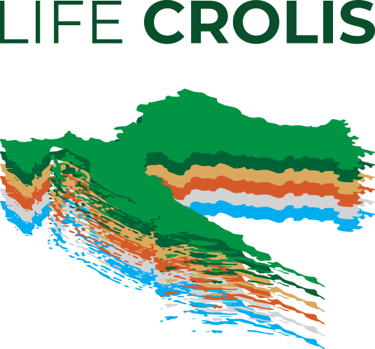
Project Logo
It consists of a stylized map of the Republic of Croatia arranged in six layers representing 6 land categories that are reported to the European Commission and the UN Framework Conference on Climate Change in the LULUCF sector. The layers represent the categories of land that are reported:
Objective 1
To develop and set-up the first multi-scale and multi-purpose land monitoring system in Croatia
Objective 2
To apply CROLIS data for the LULUCF reporting and accounting purposes in line with the requirements of international (UNFCCC, KP, PA) and EU legislation – the second demonstrative character of the CROLIS project.
Objective 3
To enable and secure a permanent CROLIS implementation by national authorities, decision makers, experts, NGOs and other stakeholders
Objective 4
To provide a robust basis for planning and implementation of GHG mitigation actions in the LULUCF sector
01
One of the most important results / effects of the establishment of CROLIS is the reduction of greenhouse gas emissions, because CROLIS is recognized as part of the solution necessary to achieve the reduction of greenhouse gas emissions and the application of measures defined within the so-called. “Climate change mitigation scenarios”.
02
The impact of CROLIS on reducing greenhouse gas emissions is expected five years after the establishment of CROLIS when CROLIS will already be used as a tool for planning climate change mitigation measures.
03
This is of particular importance in the light of the new proposal to increase the targets for reducing greenhouse gas emissions in the European Union by 2030 and to achieve a zero rate of greenhouse gas emissions in the European Union by 2050.
04
Croatian institutions dealing with land issues will use CROLIS as a source of data on land cover, land use and land management in order to meet their reporting obligations in accordance with international and EU legislation.
05
CROLIS will increase the number of relevant institutions that will be included in the Land Parcel Identification System (LPIS), ie the Croatian ARKOD. Currently, only the Agency for Payments in Agriculture, Fisheries and Rural Development (APPRRR) is included in ARKOD, but after the establishment of CROLIS, ARKOD will, in addition to APPRRR, include: Hrvatske šume doo, the Ministry of Economy and Sustainable Development and the State geodetic administration.
06
After the establishment of CROLIS, all agricultural areas will be identified and officially registered, which will enable better planning of climate change mitigation measures.
07
With the establishment of CROLIS, all bodies professionally certified for work in the field of environment will be informed about the possibilities of CROLIS and informed about the posibility of its use.
08
CROLIS Geoportal will be established as a unique source of information that will be connected to the INSPIRE Internet portal of the State Geodetic Administration.
09
A positive impact on the creation of “green jobs” is expected. Namely, the CROLIS project will employ new experts in various institutions and educate them on the use of advanced information technologies to become an infrastructure of teams for other future “green jobs”.
10
CROLIS will enable better management of the NATURA2000 network area in the Republic of Croatia, thus helping to preserve biodiversity.
11
CROLIS will be an indispensable aid in the development of numerous planning documents at national, regional and local level, spatial planning documents, etc., and it is expected that both the scientific and professional community will recognize and use CROLIS data in their work thanks to improved quality spatial data on land in the Republic of Croatia.
12
CROLIS will make it possible to reduce the uncertainty of estimating the amount of biomass available for energy needs, the current range of which is economically and environmentally unacceptable. Namely, there is currently great uncertainty in assessing the potential of using wood biomass for energy purposes, because part of the biomass originates from trees and shrubs, which grow outside the registered forest land, for example on arable land and grasslands, because the spread of forests outside the administrative boundaries of forest land not subject to monitoring. CROLIS will provide data on its biomass currently growing on different land categories which will allow for a revision of the biomass potential and will be necessary for the revision of energy and climate policy documents.
Ministry of Environmental Protection and Green Transition
The Ministry of Economy and Sustainable Development determines strategic directions, develops programs and plans for sustainable development of society based on the principle of a green and circular economy with the aim of transforming into a fair and prosperous society with a resource-efficient and competitive economy, ensuring climate neutrality, preservation and sustainable use of natural resources.
Paying Agency for Agriculture, Fisheries and Rural Development
The Paying Agency for Agriculture, Fisheries and Rural Development is a public body responsible for the operational implementation of direct support measures, rural development measures, maritime and fisheries measures (in the part of delegated functions) and joint market organization measures, as well as for keeping records and registers and for maintenance and use of the Integrated Administratition and Control System (IAKS), through which direct payments to farmers are received, processed and controlled. In coordination with the Ministry of Agriculture, it implements measures of the Common Agricultural Policy and the Common Fisheries Policy, which are financed from the state budget of the Republic of Croatia and the budget of the European Union of the Union.

Hrvatske šume d.o.o.
The mission of Hrvatske šume d.o.o. is to ensure sustainable, integral management of state forests in the entire territory of the Republic of Croatia in an ecologically sensitive, economically efficient and socially responsible manner towards the society as a whole and the company’s employees. As the leading forest management company in Croatia, Hrvatske šume d.o.o. strives to raise citizens’ awareness of forests as the national wealth of the Republic of Croatia and to promote the principles of sustainable development.
Ekonerg d.o.o.
Company Ekonerg d.o.o. has been operating in the field of energy and municipal infrastructure and industry since 1953, offering the entire cycle of services from the idea of building a facility, construction preparation (feasibility studies and cost-benefit analyses, location choice, design) to construction management, maintenance, property management and environmental impact assessment. By participating in the implementation of the largest energy projects in the Republic of Croatia and by creating a series of strategic documents in the field of energy, environmental protection and climate change, Ekonerg d.o.o. actively participates in the development of the Republic of Croatia.
State Geodetic Administration
The State Geodetic Administration is a national administrative organization that performs administrative and other tasks related to geodesy and cadastre-related tasks, especially the creation, renewal and maintenance of the real estate cadastre, computerization of the cadastre and the spatial reference system, topographical surveying and the creation of state maps, management of geodetic documentation, management of real estate and infrastructure cadastre statistical data, geodetic and cadastral affairs for the state border on land, development and application of geodetic surveying technology in science, economy-related and other activities in which spatial interventions are implemented. A special part of the work under the jurisdiction of the State Geodetic Administration is the care of the administrative, professional, development and coordination work of the National Spatial Data Infrastructure (NIPP) and the implementation of the INSPIRE directive.

The Environmental Protection and Energy Efficiency Fund
The LIFE CROLIS project, in addition to European Union funds, is co-financed by the Government of the Republic of Croatia through the Fund for Environmental Protection and Energy Efficiency.
The Fund for Environmental Protection and Energy Efficiency was established with the aim of securing additional funds for financing projects, programmes and similar activities in the field of conservation, sustainable use, protection and improvement of environmental quality. With its funds, the Fund participates in the financing of national energy programs, bearing in mind the achievement of energy efficiency and the use of renewable energy sources.
By providing support for sustainable development of the Republic of Croatia through mitigation of and adaptation to climate change, implementation of measures to reduce greenhouse gas emissions in energy, waste disposal and circular economy, industry and new technologies, preservation of biodiversity and sustainable, efficient use of resources, the Fund participates in the strategic development of the Republic of Croatia.
The Advisory Board ensures a high level of expertise and quality in the implementation of the LIFE CROLIS project. The role of the Advisory Board is to provide technical advice and guidelines on the implementation of specific activities within each implementing action of the project. The Board consists of land monitoring experts and land use, land use change and forestry (LULUCF) experts from Austria, the United Kingdom and Croatia.
The engagement of experts with specific experience and knowledge is key to fulfilling contractual obligations by ensuring the necessary level of expertise in the use of relevant national base documents and existing EU products (e.g. High Resolution Layers, LUCAS), in order to establish a multi-purpose land monitoring system as a basis for development planning based on low levels of carbon dioxide by 2030, i.e. 2050 in the LULUCF sector, in accordance with the initiated activities of the EU Copernicus programme and the work of the EAGLE Group.
The LIFE CROLIS project is co-financed by the LIFE programme of the European Union. The project is co-financed by the Government of the Republic of Croatia through the Environmental Protection and Energy Efficiency Fund. The project is co-financed by partner institutions using their own funds.
EU co-financing: EUR 2,588,207
Co-financing by the Government of the Republic of Croatia through the Environmental Protection and Energy Efficiency Fund: EUR 947,946
Co-financing by the Ministry of Economy and Sustainable Development: EUR 2,241,927
Co-financing by EKONERG d.o.o.: EUR 330,518
Co-financing by the Paying Agency for Agriculture, Fisheries and Rural Development: EUR 100,528
Co-financing by the State Geodetic Administration: EUR 22,003
Co-financing by Hrvatske šume d.o.o.: EUR 17,606