
More about LIFE CROLIS project
CLIMATE CHANGE AND MITIGATION AND POLICIES FOR ADAPTATION TO CLIMATE CHANGE IN THE EUROPEAN UNION
Rapid development as a result of the industrial revolution and a large increase in the number of people on Earth in the last hundred years have caused significant changes of the climate. Greenhouse gas emissions caused by human activity, primarily those caused by the burning of fossil fuels, are largely responsible for climate change, which is increasingly encroaching on everyday human life. The burning of fossil fuels contributes to the increase in the concentration of carbon dioxide and other gases in the atmosphere and thus affects the intensification of the greenhouse effect and global warming. We are already witnessing the consequences of climate change, and the assumptions are that there will be increasingly strong negative effects, which will be irreversible. Simulations based on advanced scientific models indicate that the extent and intensity of the negative consequences of climate change will depend on the success of implementation of policies and measures for mitigating and adapting to climate change.
Comprehensive reports on climate change by the Intergovernmental Panel on Climate Change (IPCC) of the United Nations and the World Meteorological Organization (WMO) show that greenhouse gas emissions at the global level continue to grow, and the extent and intensity of the impact of climate change is greater than previously estimated. In order to remain on the trajectory of limiting the increase in global temperature to 1.5 °C, in accordance with the Paris Agreement, it is necessary to set more ambitious goals and obligations to reduce greenhouse gas emissions of all countries. For this reason, in December 2019, the representatives of the EU member states adopted the goal of achieving climate neutrality in the European Union by 2050. In order to achieve this goal, a new, even more ambitious goal of reducing emissions in the European Union by 55% by 2030 was adopted in December 2020. In accordance with this goal, adaptation of the entire legislation of the European Union started and this new legislative package is known as “Fit for 55”.
In addition to the new objective of reducing emissions, this climate and energy package of the European Union also introduces the objectives of increasing the share of renewable energy sources in total energy production and increasing energy efficiency, as well as climate goals in all sectors.
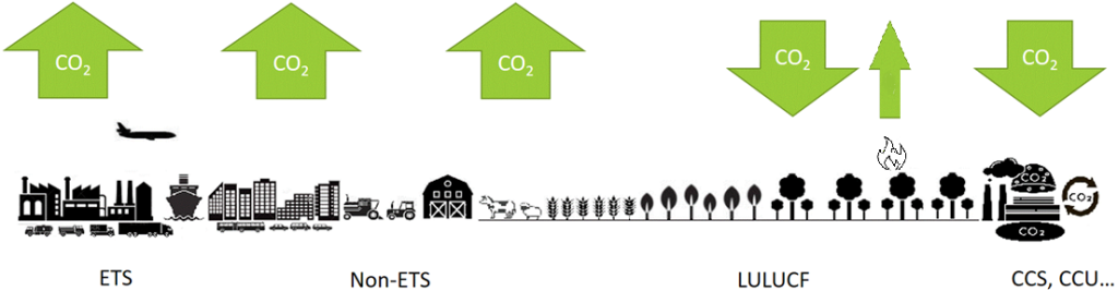
The stated objectives are to be achieved in sectors within the EU greenhouse gas emissions trading system (EU ETS) (e.g., large power plants) and outside that system (e.g., agriculture, waste) (non-ETS), as well as in the land use, land use change and forestry sector (LULUCF). Annual emission quotas are established for sectors outside the EU greenhouse gas emissions trading system of the European Union member states, and these quotas may not be exceeded by the member states. In addition, each European Union member state must ensure such conditions that from 2021 to 2030, greenhouse gas emissions in the LULUCF sector do not exceed their removals. By 2030, removals must increase to -310,000 kt CO2-eq at the EU level, and it has been determined how much each EU member state should contribute to achieving that goal. For the Republic of Croatia, that goal in 2030 amounts to -5,527 kt CO2 eq.
What is LULUCF?
For monitoring of greenhouse gas emissions from a large number of human activities, such emissions are classified into six sectors: energy; industrial processes and product use; agriculture; land use, land use change and forestry (LULUCF); waste and other. Data on emissions from these sectors help countries plan and implement policies and measures to reduce emissions and increase carbon removal (carbon sinks).
LULUCF is an abbreviation that stands for the land use, land use change and forestry sector. LULUCF is used in implementing various activities (planning, implementation and monitoring of implementation policies, monitoring of the environment and climate, development and application of various models…) linked to climate change and sustainable development in order to include activities that affect the amount of greenhouse gases in the atmosphere and are connected with land and forest management.
LULUCF encompasses various aspects. “Land use” refers to the change of land use, such as the conversion of forests to agricultural land or urbanization. “Land use change” refers to natural or human activities that change the way existing land is used, such as deforestation or forest restoration after a fire. “Forestry” refers to the management and stewardship of forests, including logging and afforestation.
It is important to monitor and understand greenhouse gas emissions resulting from these activities because land and forests act as carbon sinks (storage), absorbing and retaining greenhouse gases from the atmosphere. However, changes in land use and forestry can also lead to the release of significant amounts of greenhouse gases, especially if natural ecosystems are disturbed or destroyed. LULUCF is used in international documents, such as the United Nations Framework Convention on Climate Change (UNFCCC), to estimate greenhouse gas emissions and carbon sequestration associated with land use and forestry activities. These data help countries understand and monitor their greenhouse gas emissions and develop policies and measures to reduce these emissions and preserve forests and ecosystems.
THE SIGNIFICANCE OF THE LULUCF SECTOR IN MITIGATION AND ADAPTATION TO CLIMATE CHANGE
In the LULUCF sector, emissions and removals of carbon dioxide from the atmosphere are monitored across six categories of land: forestland, cropland, grassland, wetlands, settlements and other land. Land use change refers to change in the way land is used, such as, for example, turning grassland into cropland or into forest land by implementing afforestation, or reclamation of wetlands and turning the land obtained in this manner into grassland or agricultural land, etc.
It is especially important to monitor and understand the processes that lead to greenhouse gas emissions in the LULUCF sector, because it is the only sector in which carbon dioxide is removed (carbon sinks) from the atmosphere naturally and through its storage in natural reservoirs (vegetation, soil, wood products). However, changes in the LULUCF sector can lead to the release of significant amounts of greenhouse gases, especially if natural ecosystems are damaged or destroyed.
In order to achieve climate neutrality and zero greenhouse gas emissions (emissions equal to removals) on a global scale, it is necessary that the emissions remaining after taking appropriate actions for their reduction in the EU ETS sectors and sectors outside the EU ETS are balanced by carbon dioxide removal through permanent storage in natural carbon sinks (vegetation, soil, dead wood, leaves, wood products) or through technological storage. Global net zero carbon dioxide or greenhouse gas emissions can be achieved even if some sectors and regions have greater net emissions than removals, provided that other sectors and regions achieve net negative emissions. It is clear that this will require understanding and broad cooperation among all countries of the world.
A prerequisite for planning and monitoring of all the stated objectives is the collection and processing of a large amount of data, from data on emissions by sectors to a range of spatial data in the LULUCF sector. The greatest value of the LIFE CROLIS project is precisely that its implementation will help develop the tools necessary for the collection and processing of spatial data for the purpose of monitoring greenhouse gas emissions and sinks in the LULUCF sector, and it will be possible to apply them in other countries as well. The value of this project was also recognized by the European Commission, which cited it as an exemplary system for collecting and processing spatial data for the stated purpose.
One of the main challenges, but also the main basis for any greenhouse gas balance in the LULUCF sector, is the detailed information on land use (LU) and land cover (LC), defined as a matrix of land use and land use change over time. Currently, in almost all EU member states, the matrix of land use and land use change is insufficiently precise with regard to the criteria set for reporting according to the new LULUCF regulation. Data on the areas of individual land categories, including data on the conversion of one land category to another on an annual basis, starting in 1970, should be accurately determined in terms of space.
In addition to meeting the given criteria, member states must bring together different sources of information on land cover and land use in order to develop a complete and consistent matrix of land use, land use change and forestry. The lack of appropriate tools represents the biggest challenge for the realization of this task.
EAGLE CONCEPT AND CROLIS
Within the European Environment Agency (EEA), the European Environment Information and Observation Network (EIONET) was established as a central place for collecting environmental data from different sources and for different purposes, which are available to all member states. The data provided by member states or various European institutions must be uniform in quality and standardized within this network.
The EIONET Action Group on Land Monitoring in Europe (EAGLE), which consists of the top European Union experts in the field, aims to develop a concept and methodology that will improve European information capacity for land monitoring.
EAGLE utilizes the concept of separating spatial data into two separate data sets: land cover data and land use data. This concept is a means of comparing and harmonizing meaning between different land cover and land use designation systems. Some of its comparative advantages are: it is applicable at both the European Union and the national level, it is open for application as a standard for collecting land cover and land use data and it can serve to harmonize and define a common framework for the products of the COPERNICUS Programme. The EAGLE concept is being considered as part of the CROLIS project for the purposes of developing a single database for CROLIS.
With the aim of identifying, monitoring and historical overview of the state of and changes in land use and land cover, CROLIS will be developed by combining existing nationally available spatial data on land use and land cover, available products of the Copernicus Programme, available satellite images (Sentinel, SPOT, Landsat) and, as part of the CROLIS project, generated ARKOD+ data.
Contribution of the LIFE CROLIS project to the implementation of EU climate policies
Anthropogenic GHG emissions are responsible for climate change in the last decades. Model simulations indicate continuation of climate change depending on success and implementation of mitigation measures. The most significant sources of GHG emissions in the Republic of Croatia are the following sectors: Power engineering, Industrial processes and use of products, Agriculture and Waste.
The only sector that is not a source of emissions for now is the Land Use, Land Use Change and Forestry (LULUCF) sector. However, if there are fewer carbon sinks as a result of excessive and uncontrolled cutting and degradation of forest land, then this sector could have greenhouse gas emissions greater than the sink and therefore have a multiple negative impact. Namely, the burning of wood is a source of greenhouse gas emissions, which simultaneously reduces the capacity of the most powerful natural mechanism for removing carbon dioxide from the atmosphere – the photosynthesis of green autotrophic organisms.
Monitoring of greenhouse gas emissions in the land use, land use change and forestry sector is the basis for determining the impact of that sector on the greenhouse gas balance of all sectors. However, monitoring emissions in that sector is more complicated and demanding than monitoring greenhouse gas emissions in other sectors. As a consequence, data on emissions in this sector are mostly imprecise and insufficiently comprehensive.
One of the major challenges but indispensable basis for any GHG balance in the LULUCF sector is detailed and nation-wide information on LC, LU and land management known as the land use and land change matrix. In almost all Member States this matrix contains incomplete information, considering the reporting requirements such as:
• Data consistency over time
• Data completeness by sectors, management activities and all required reporting years
• Sufficient consideration of all potential impact (e.g. agricultural management, soil)
• Explicit spatial LC and LU data
In addition, the MSs have to compile various sources of LC and LU information to develop a complete and consistent LC and LU matrix. Appropriate tools for such a task do not exist.
FUTURE POTENTIAL OF THE CROLIS (AfterLIFE PLAN)
We are building the CROLIS as a basis for different types of reporting according to the requirements of different users. The advantage of the CROLIS is that data from different institutions will be processed and prepared for use in accordance with user requirements. Overlaps between data from different sources will be mutually harmonized according to clearly defined criteria and rules contained in the project development document, “CROLIS Plan” (Croatian National Land Information System Maintenance Plan), which will be written after the establishment of the CROLIS within the project. The CROLIS organized in this way will represent a solid basis for future extensions to monitoring new data and reporting on them by adding new layers to the already prepared database and a functional system for their processing. The “AfterLIFE Plan” will help in this, ensuring long-term fulfilment of the project goals after the end of the project.
The latest legislative proposals of the European Union have been prepared with the aim of more precise monitoring of the situation and the preparation of appropriate reports based on georeferenced data of greater precision. Some of the proposed or already adopted acts are: Regulation (EU) 2023/1115 on the making available on the Union market and the export from the Union of certain commodities and products associated with deforestation and forest degradation, the proposal for a regulation on the establishment of a Union framework for certification of carbon removal, the proposal for a directive on soil monitoring and resistance (soil monitoring act) and the proposal for a regulation on the restoration of nature. The CROLIS project lays the foundation for future monitoring and reporting in accordance with the requirements of these four new EU legislative acts. For example, when it comes to certification of carbon removal, it will be necessary to georeference the areas of forests that are managed as carbon storage sites, while when it comes to soil monitoring, it will be necessary to georeference the areas that are in the monitoring system. Regarding restoration of nature, it will be necessary to georeference monitoring sites of different levels of nature protection.
In proving the sustainability of the origin of biofuels according to the Directive on the promotion of the use of energy from renewable sources, it is necessary to analyse the impacts of land use changes, including those that may occur outside the project, the so-called indirect land use changes (ILUC).
Additional capabilities of the CROLIS and the up-to-dateness of the data that the system will process and prepare will enable its use for the national requirements of government bodies, the economy, the academic community and the non-governmental sector. It will be possible to use the system when creating various strategic and planning documents in the fields of climate, energy, biodiversity protection, agriculture and forestry.
The pressure on space is increasing, due to the need to preserve food production, the use of biofuels, the requirements of bioeconomy, increasing carbon sequestration, in addition to the need to preserve biological diversity and natural habitats, the quality and abundance of surface and underground waters. Good-quality georeferenced information on space use and land cover is a prerequisite for sustainable development.