
02.06.2023
Presentation of Ekonerg on the development LU and LC layers for Croatia
On April 16th, 2024, the experts of Ekonerg d.o.o. – Institute for Energy and Environmental Protection held a presentation on activities on the development of Land Use (LU) and Land Cover (LC) layers for Croatia for the reference year of 2020. The presentation was held online, only for project partners and is just one in a series of presentations held at the project in order to exchange information and and harmonize project partners.
Nino Malešić presented the current draft of the Land Use (LU) layer and the first conclusions regarding the anticipated challenges in the analysis of land surfaces in the historical period (1968 – until 2019). The current LU layer was created with the application of the recommendations of the members of the CROLIS Advisory Board regarding the upgrade of the then existing version of this layer, and included implementation of rasterization of the vector into a raster layer with a resolution of 5m x 5m instead of the previously used 10m x 10m and the application of the quality assessment of data sources in the development of individual LU classes in such a way that sources with higher reliability are given higher priority when filling the gaps that remain after the rasterization process.
The implementation of these recommendations by the Advisory Board members resulted in increased area in the Urban use class of the LU layer from the previous 179 kha to the current 264 kha, and a special improvement in the identification of areas was recorded in the Level 2 Transport & Logistics use class. This class of the LU layer in all previous versions of the LU layer is recognized as the class with the largest deviation in the total area compared to the data used for the purposes of reporting emissions/discharges in the LULUCF sector. One of the reasons for such deviation is considered to be the representation of railroads as linear objects in the original data.
For the purposes of implementing the first analysis in the development of the LU/LC layer during the historical period, spatially precisely defined data on the conversion of land into and from the Forest land category were used.
For randomly selected, exemplary areas that were the subject of afforestation or clearing in a specific year, using satellite SPOT images, the condition was checked in the period after 10 or 20 years.
For data from the forestry sector for which the so-called Approach 3 in land identification and monitoring has yet to find the best way to apply it in the CROLIS project and the implementation of C2 project activities.
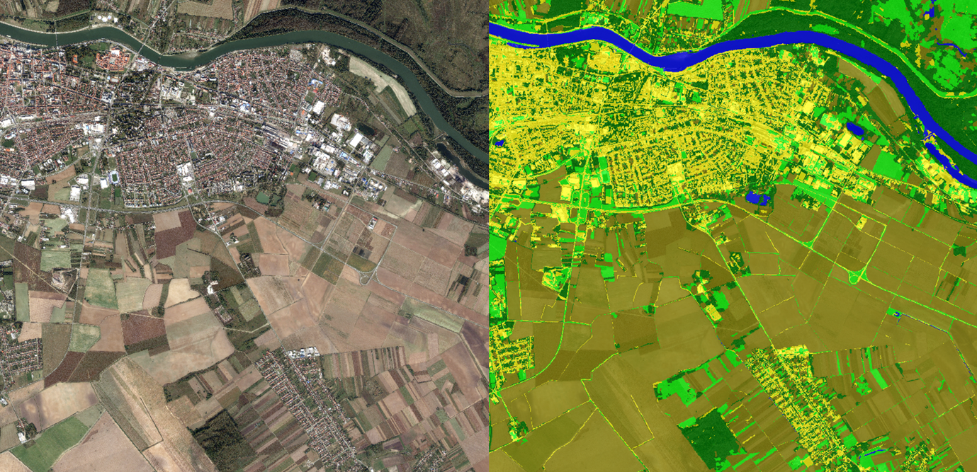
Marina Kukavica presented the current results in the development of the LC layer. The methodology, which is still under development and is expected to be continuously upgraded during the duration of the project, was developed in the test area of Istria and then applied to the test area of the city of Osijek and its surroundings. Although these are two fundamentally different parts of Croatia, the results obtained on the currently analyzed surfaces show satisfactory results (high reliability and corresponding kappa coefficient). The applied methodology (OBIA) includes the segmentation of ortho-photo shots, assigning categories, taking training samples for the so-called machine learning and implementation of automatic classification based on Lidar nDSM raster data, DOF5, Sentinel-2 images, spectral radiometric indices, as well as geometric characteristics of segments.The currently proposed six classes of the LC layer will be further discussed in the project, and the need to introduce additional classes (fe. urban greenery) will be assessed.
The presentation was held as part of the project activities C1 CROLIS data concept & model and C2 Sample- based system for historic land cover (LC) and land use (LU).
Share this news: